


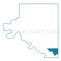
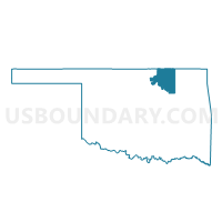
Voting District 204, Osage County, Oklahoma
About
Outline

Summary
| Unique Area Identifier | 654904 |
| Name | Voting District 204 |
| County | Osage County |
| State | Oklahoma |
| Area (square miles) | 50.04 |
| Land Area (square miles) | 49.53 |
| Water Area (square miles) | 0.51 |
| % of Land Area | 98.99 |
| % of Water Area | 1.01 |
| Latitude of the Internal Point | 36.26549740 |
| Longtitude of the Internal Point | -96.08184590 |
Maps

Graphs
Select a template below for downloading or customizing gragh for Voting District 204, Osage County, Oklahoma


Neighbors
Neighoring Voting District (by Name) Neighboring Voting District on the Map
- Voting District 1, Tulsa County, OK
- Voting District 202, Osage County, OK
- Voting District 203, Osage County, OK
- Voting District 206, Osage County, OK
- Voting District 3, Tulsa County, OK
- Voting District 305, Osage County, OK
- Voting District 306, Osage County, OK
- Voting District 308, Osage County, OK
- Voting District 309, Osage County, OK
- Voting District 551, Tulsa County, OK
- Voting District 553, Tulsa County, OK
- Voting District 9, Tulsa County, OK
Top 10 Neighboring County Subdivision (by Population) Neighboring County Subdivision on the Map
Top 10 Neighboring Place (by Population) Neighboring Place on the Map
- Tulsa city, OK (391,906)
- Sand Springs city, OK (18,906)
- Skiatook town, OK (7,397)
- Sperry town, OK (1,206)
Top 10 Neighboring Unified School District (by Population) Neighboring Unified School District on the Map
- Tulsa Public Schools, OK (284,811)
- Sand Springs Public Schools, OK (25,005)
- Skiatook Public Schools, OK (11,979)
- Sperry Public Schools, OK (5,388)
- Prue Public Schools, OK (2,697)
Top 10 Neighboring State Legislative District Lower Chamber (by Population) Neighboring State Legislative District Lower Chamber on the Map
- State House District 36, OK (37,155)
- State House District 35, OK (36,242)
- State House District 73, OK (32,082)
Top 10 Neighboring State Legislative District Upper Chamber (by Population) Neighboring State Legislative District Upper Chamber on the Map
- State Senate District 34, OK (88,558)
- State Senate District 10, OK (76,617)
- State Senate District 11, OK (66,456)
Top 10 Neighboring 111th Congressional District (by Population) Neighboring 111th Congressional District on the Map
Top 10 Neighboring Census Tract (by Population) Neighboring Census Tract on the Map
- Census Tract 9400.10, Osage County, OK (6,952)
- Census Tract 9400.07, Osage County, OK (4,674)
- Census Tract 79, Tulsa County, OK (4,636)
- Census Tract 9400.05, Osage County, OK (3,921)
- Census Tract 9400.09, Osage County, OK (3,216)
- Census Tract 80.02, Tulsa County, OK (2,791)
- Census Tract 91.01, Tulsa County, OK (2,683)
- Census Tract 56, Tulsa County, OK (2,504)
Top 10 Neighboring 5-Digit ZIP Code Tabulation Area (by Population) Neighboring 5-Digit ZIP Code Tabulation Area on the Map
- 74063, OK (29,808)
- 74106, OK (17,648)
- 74127, OK (17,151)
- 74070, OK (13,928)
- 74126, OK (10,598)
- 74073, OK (5,118)
- 74060, OK (586)